Zoning: The Key to Vienna’s Commercial Redevelopment
By Frank DillowMarch+April 2019
WHEN AUTOMOBILES FIRST APPEARED on Vienna’s streets around 1904, the speed limit in town was set at 12 mph. For today’s commuters attempting to navigate Maple Avenue – Vienna’s main thoroughfare – during morning and evening rush hours, 12 mph would be a considerable improvement.
"Most growth over the next 30 years will happen in strip commercial redevelopments." - Christopher Leinberger, George Washington University School of Business
The first shopping center opened on Maple Avenue in 1954 to provide commuters with convenient places to stop and shop as they drove to and from their suburban homes. Since then, the street has been transformed from a maple-lined country road rolling through Vienna’s bucolic downtown into a four- lane thoroughfare navigating a maze of asphalt parking lots and retail centers.
Zoning is one of a community’s strongest tools to control property development, particularly the type of development and where it will be allowed. In Vienna, development has largely been the result of a zoning ordinance adopted in 1969 when many of today’s suburban baby boomers were still being driven from place to place in their parents’ station wagons.
In 2014, exactly 60 years since the first shopping center opened its doors, Vienna’s Town Council approved a more flexible revised zoning ordinance known as the Maple Avenue Commercial (MAC) zone in an attempt to attract development that would recapture Vienna’s small-town identity.
According to Vienna’s Maple Avenue Vision statement, “MAC reinforces Maple Avenue’s role as the town’s main street.” It encourages developers to design their plans around “pedestrian friendly mixed-use projects,” rather than the automobile-oriented strip mall development that currently dominates Maple Avenue.
Vienna’s interest in rethinking its downtown comes as suburban communities throughout Northern Virginia react to residents and developers seeking to transform existing retail outlets into more modern lifestyle community centers featuring restaurants and entertainment.
The nearby Mosaic District is a good example. With better access to the Vienna/Dunn Loring Metro stop than downtown Vienna, Mosaic has become a highly successful center in the past few years. With multifamily housing, boutique shopping, dining, a hotel and a movie theater, Mosaic welcomes those eager to shop, eat, be entertained or just meet their neighbors.
Mosiac was developed and is owned and operated by Edens, a company that proclaims on its website that its work is “bigger than real estate,” and its purpose is to “enrich community through human engagement.”
Christopher Leinberger, professor of urban real estate at the George Washington University School of Business, is one of the country’s leading proponents of the notion that the future will be one of “walkable neighborhoods.”
“The postwar era of automobile- oriented ‘drivable suburbanism’ is over,” he predicted six years ago in a report entitled “DC: The WalkUP Wake-Up Call.”
“Most growth over the next 30 years will happen in strip commercial redevelopments,” Leinberger predicted. While he had Tysons in mind when he wrote the report, his observations may also apply on a smaller scale to recent developments in communities like Vienna.
A change in Vienna’s commercial development is already underway with the Town Council’s approval last fall of the 444 Maple West project, which covers nearly three downtown acres and will allow the demolition of an existing three-story hotel with 179 rooms and a stand-alone restaurant at the corner of West Maple and Nutley Streets.
In its place a four-story mixed-use development will be constructed, with 151 multifamily residential units atop 20,000 square feet of commercial retail and restaurant space.
A report in 2002 sponsored by the National Association of Realtors® and produced by the Local Government Commission entitled “Creating Great Neighborhoods: Density in Your Community,” observed, “To create great communities, neighborhoods must combine density with great design.”
Pointing to Arlington County as an example, the report noted the growing public realization that “adding density in appropriate locations can create great places to live.”
Increasingly, people understand that to achieve their community goals and create a vibrant place to live, the community needs different types of development – different types of density. “[The community] cannot thrive over the long-term with only one development choice,” the NAR- commissioned report concluded.
As Northern Virginia continues its rapid commercial transformation, Realtors® should be looking beyond the current well-publicized developments in Tysons, Reston or Arlington County, to expanded opportunities in the commercial redevelopment occurring in older, more established communities such as Vienna.
|
Important Changes Coming
The portion of the sub-unit located at the corner of Lee Highway and Cedar Lane [Parcel 49-3((1)) 60] is planned for and developed with office use at up to .35 FAR. The portion of the sub-unit fronting on Lee Highway east of Parcel 60 [Parcels 49-3((27)), 49-3((1)) 59 and 61] is planned for and developed with low-rise office and retail up to .35 FAR.
Sub-Unit E5 is located east of Cedar Lane along the south side of Lee Highway and is planned and developed with retail uses at current intensities. Any modification, expansion, and/or reuse of the existing buildings should be consistent with guidelines for Existing Uses and Buildings under the Area-Wide Land Use section. Option: The widening of Lee Highway may make the residual property too narrow for continued retail or commercial use. If that is the case, the residual property may be appropriate for use as a park or open space or for governmental and institutional uses. See the Transportation section of the Area-wide Recommendations for the policy concerning right-of-way acquisition. Height Limit: The maximum building height in this sub-unit is 40 feet. See the Building Heights Map, Figure 16, and the Building Height Guidelines under the Area-Wide Urban Design section.
Sub-Unit E6 Sub-Unit E6, Parcel 49-3((1)) 51A, fronts on Lee Highway and is planned for and developed with office use up to .35 FAR. Any modification, expansion, and/or reuse of the existing buildings should be consistent with guidelines for Existing Uses and Buildings under the Area- Wide Land Use section. The existing buffer along the southwestern portion of the property adjacent to the existing residential neighborhood should be preserved. In addition, the Long Branch Stream Valley along the property’s western boundary should be preserved as private open space. Height Limit: The maximum building height in this sub-unit is 40 feet. See the Building Heights Map, Figure 16, and the Building Height Guidelines under the Area-Wide Urban Design section.
The following transportation policy recommendations offer additional guidance for development within the Merrifield Suburban Center: Right-of-way Acquisition Policy – In order to achieve the Merrifield Suburban Center objectives, any development proposal should dedicate right-of-way for planned road improvements. In addition, VDOT should, in some instances, obtain right-of-way (ROW) from one side of the street rather than taking equal amounts of right-of-way from both sides. For example, the north side of Lee Highway, between Cedar Lane and Old Lee Highway, has relatively new development, whereas the development on the south side of Lee Highway in this same area is significantly older. An equal taking from both sides of the road would significantly affect the viability of the uses on both sides of the road, whereas entire ROW takes from the south side of the road would allow the businesses on the north side to remain viable. Any excess property resulting from right-of-way acquisition should be used for linear parks and/or public facilities uses that do not need as much property depth as a retail use. In addition, surplus property from ROW acquisition may create opportunities to further the Merrifield Suburban Center objectives, such as adding the surplus land to an abutting property, when it facilitates desired redevelopment.
Read the full plan from Fairfax County here.
|
Caboose Approved to Convert an Old Warehouse into a Brewery in the Mosaic District
|
Craft beer maker Caboose got approval to serve up its pilsners, Berliner Weisse and other microbrews, along with its farm-to-fork dishes, at a new brewery in Mosaic.
They will convert an old warehouse on Eskridge Road, just south of Lee Highway, into a brewery and restaurant. The plans for the new brewery include about 160 seats, a 3,240-square foot tasting room, and beer garden on the building’s south side.
The Board of Supervisors signed off on these plans on Tuesday. This will be the second location for the one-year old brewery founded by two former local tech executives.
Caboose says that it expects that its new brewery will open next year. The brewery’s plans also make improvements to the existing site, including a landscaped, urban green area with benches, public art, bike racks and space for a future bikeshare station.
They also will build an eight-foot wide sidewalk along Eskridge Road, as well as a new crosswalk to connect with Mosaic’s Strawberry Lane. The plans also include a six-foot wide path through the urban green connecting to the sidewalks at Hilltop Road and Lee Highway.
Click here to read more.
|
Mosaic turns construction into art with Mosaic Yards ProjectPosted by Editorial / Monday, January 12th, 2015 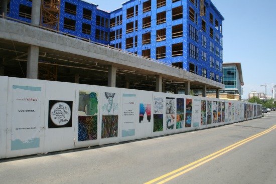 Photo courtesy of EDENS By Michael Balderston The Mosaic District in Fairfax is constantly growing, offering new shops, restaurants and entertainment to the community with its unique style and design. This means a lot of construction has and continues to take place at the shopping center. But rather than throw up a plain wall around construction sites, Mosaic has found a way to add their unique touch with theMosaic Yards program. If you’ve visited Mosaic at any time over the last year you have likely seen the project – 150 paintings decorating the walls around the construction of the upcoming Modera Mosaic apartment buildings. Among those paintings are the works of professional artists, children from Inova Hospital and even Edens’ marketing director Angela Rakis’ mother. “Mosaic’s vision has always been to be a part of the community and enrich that area and we believe art is a part of that,” says Rakis. “It really was just a big white wall and it was screaming for something; something creative, something innovative, something fun that would engage our community.” To fill that space Mosaic allowed artists to create their own works of arts on yard-length panels, uniquely expressing themselves. “Each one is not a Picasso or a work of fine art,” says Rakis, “but each one represents a little piece of our community and that’s what’s really cool about it.” One artist represented in the project is local professional Jessica Kallista. She has two works currently on display and reached out to others local artists about this opportunity to show off their work. “It’s really good they are trying to transform the space at Mosaic so art is there,” says Kallista. “It’s really fantastic for the community, for artists and for art lovers as well.” At least in its current iteration, Mosaic Yards won’t be around for too much longer. With construction coming to a close on the Modera apartments, Mosaic will be finding new homes for the paintings. Some won’t be going very far at all, as Modera has agreed to use a number of the works in the lobby and hallways of their building. The remaining paintings will find new homes either in a similar capacity around constructions sites as Mosaic continues to expand, or elsewhere within the shopping center. Mosaic’s mission is to create community engagement to establish “the most innovative retail & entertainment community.” Mosaic Yards is certainly a strong step in that direction.
|
No Parking, No Problem
Transit-oriented developments are reflecting the preferences of today’s younger professionals. Learn what leading-edge developers are thinking.

Millennials are driving today’s transformation of major urban centers, according to a fall 2014 Cushman & Wakefield report. Many are opting to ditch cars as long as they can live within walking distance of amenity-rich areas and easily catch transit when they’re looking to venture beyond their neighborhood hub. In just six years, C&W reports, they’ll make up more than half of the global workforce. This expanding cohort of workers born since 1982 is likely to turbocharge another phenomenon with important ramifications for commercial practitioners: the demand for so-called transit-oriented development.
These mixed-use areas in cities and suburbs are located a half-mile or less from public transportation and typically occur in higher-density communities. Along with improving access to jobs, such developments spur other benefits, including reductions in driving rates, road congestion, and greenhouse gas emissions. Perhaps the most radical departure of all from conventional development priorities, onsite parking is typically a minimal or nonexistent part of the plan.
However, like the millennials themselves, TODs have matured since they first emerged. In some cases, neighborhood activists are pushing for TODs. And where they’re not on consumers’ radar, developers are fine-tuning their strategies to seek meaningful community involvement. Smart developers understand they need to offer more than just proximity to transit. Their projects need to reflect the changing lifestyles of younger consumers who are more likely to be tethered to their electronic gadgets than to a vehicle—a reality that lenders are starting to grasp as well.
Since the late 1990s, TOD has been a force in the development world, says David Dixon, an urban planner at Stantec in Boston. The Great Recession, however, changed TOD’s trajectory.
“Transit’s ability to really incent development—and a different kind of development, of walkable communities—first became recognized in the late 1990s and early 2000s,” he explains. “But coming out of the recession there’s been so much more awareness of the power of cities to attract people, the interest in walkable environments, and the desire to not have a car. ”
Data has begun emerging showing that TOD improves property values. A 2009 study by CEOs for Cities found that in 13 of the 15 markets analyzed, increased walkability in a neighborhood was directly linked to higher home values.
Fitzhugh Stout, senior managing director of the Charlotte, N.C., office of Integra Realty Resources, a real estate valuation company, studied the effect of a light rail line that opened in his area in 2007. He found properties had increased in value from 5 percent to 73 percent since then, and the most dramatic increases came from changes in zoning that permitted increased density. “Everywhere in the country, people talk about reducing parking and getting higher density in development,” he says. “Transit has allowed that to happen.”
...
Jackson agrees with colleagues that planning for parking can be tricky. At Shady Grove, townhomes have attached parking for one or two cars while rentals have fewer allotted parking spaces. “One consideration is who’s moving into the units. You may be doing larger units targeted for empty nesters. They may be less willing to give up their cars,” he says. You also have to think about what amenities are within walking distance. The higher the Walk Score, the less parking you need.
Bottom line: You can’t just throw up a development near a subway station and call it a day. Transportation (and not necessarily rail; good bus service also qualifies), walkability, and neighborhood amenities are all factors in successful TOD, he says. “It’s a dynamic analysis.”
|
|
|